First Nine Weeks
TEST – Map Skills – 8/12/11
TEST – Map Skills – 8/12/11
1. What is used to find the distance between 2 points on a map?
a) Scale b) compass c) legend d) title
2. North, south, east and west are called cardinal directions.
3. Northwest, northeast, southwest, and southeast are called intermediate directions.
4. What part of a map is used to find orientation (what direction you are going)?
a)Latitude lines b) scale c) legend d) compass rose
5. What type of lines are used to find elevation?
a)scale lines b) latitude lines c)contour lines d)longitude lines
6. Latitude lines are used to measure distance _______________ or _________________ of the equator.
a) up or down b) north or west c) north or south d) east or west
7. What is used to find absolute location on a map?
a) latitude and longitude lines b) compass rose c) latitude lines d)scale
8. If you are traveling from point A to point B, what direction are you travelling in?
B
| ||||
A
| ||||
N
á
a) Northeast b) Southeast c) Northwest d) Southwest
9. The Persian Gulf is known as _________________________________ in Saudi Arabia.
a) Gulf of Arabia b) Arabian Gulf c) Persian Sea d) Gulf of Persia
10. In Korea the Sea of Japan is called the ____________________________.
a) East Sea b) Sea of Korea c)Gulf of Korea d) East China Sea
11. The title explains the theme/content/focus of the map and gives you an idea of what the main idea or information is about.
12. Labels do what on map: list the names under all cities, counties, territories, symbols, etc.
12. Labels do what on map: list the names under all cities, counties, territories, symbols, etc.
13. The map legend/key lists and explains all symbols, colors, etc.
14. Lines of latitude are imaginary lines that measure distance north or south of the equator and run from east to west on the map.
15. These lines are also called parallels because they do not touch.
16. Some important lines of latitude are:
A. Equator 0
B. Tropic of Cancer 23.5 N
C. Tropic of Capricorn 23.5 S
D. Arctic Circle 66 N
E. Antarctic Circle 66 S
17. Lines of longitude are imaginary lines that measure distance east or west of the Prime Meridian and run from north to south on the map.
18. These lines connect at the north & south poles.
19. These lines are also called meridians .
20. Absolute Location is an exact location on the map.
21. Latitude and longitude is used to find absolute location.
22. Relative location IS or IS NOT an exact location. (Circle one)
23. Relative location can be found by general directions, or approximate mileage from point A to point B.
24. Scale shows the ratio between a unit of length on the map and a unit of distance on the earth.
24. Scale shows the ratio between a unit of length on the map and a unit of distance on the earth.
25. List the seven continents: North America, South America, Asia, Europe, Australia, Africa, Antarctica
26. List the five oceans: Pacific, Atlantic, Indian, Arctic, Southern
27. Draw a compass rose with the cardinal directions.
26. List the five oceans: Pacific, Atlantic, Indian, Arctic, Southern
27. Draw a compass rose with the cardinal directions.
28. Draw a compass rose with the intermediate directions.
29.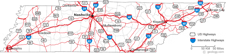
Using the scale of this map, how many miles is it from Memphis to Nashville?
Approximately 200 m.
Approximately 200 m.

30. Name three states that extend below latitude 30 degrees N (in the contiguous US), and label them on the map. Texas, Louisianna, Florida
31. Name one US state that is mostly east of longitude 70 degrees W, and label it on the map.
Maine
32. Name three US states (shown on this map) that extend west of longitude 120 degrees W, and label them on the map. Washington, Oregon, California33. Is the location 45 degrees N latitude, 82 degrees W longitude on land or under water? On the map, mark it with a red X. Under water
34. Name the state that is located entirely between 40-45 degrees N latitude and between 90-100 degrees W longitude, and label it on the map. Iowa
___________________________________________________________________________________
Map Projection & Different Types of Maps Notes - 8/15/11
Map Projections - Part 1 of Quiz
Map projections are _____________________________________________________
______________________________________________________________________
______________________________________________________________________
1. Mercator Projection
The Mercator Projection is used by ______________________________________
How to identify it
a.
b.
c.
2. The Polar Projection is used by _______________________________________
How to identify it
a.
b.
c.
3. The Robinson Projection is used by ___________________________________
a.
b.
c.
Different Type of Maps
Political Maps
Physical Maps
Topographic Maps
Thematic Maps
Cartograms
1. Political maps show human made features such as ___________________________
_______________________________________________________________________
2. Physical maps help you see the type of ____________________________________
_______________________________________________________________________
3. Thematic maps show specific types of information. Some examples of thematic maps are:
Population distribution and density
Economic activity
Resource
Language
Ethnicity
Climate
Precipitation
Vegetation
4. Small Scale Maps
Maps can be _________________________________
A small scale map show a _____________________________________________
A small scale map is used to see ____________________________________________
5. Large Scale Maps
A large scale map shows a _________________________________________________
A large scale is used to see _________________________________________________
_________________________________________________________________________________
8/17/11
Map Types - Part 2 of Quiz
1-3: Fill in the blank with the correct answer (Political Map, Physical Map, or Thematic Map)
1) A map that is used to show land features such as mountains, rivers, forests, and plains is called a ________________________________.
2) A map that is used to show boundaries of countries, counties, cities, or states is called a ________________________________.
3) A map that is used to show information about an area, such as population, rainfall, age, birth rates, and trends is called a ______________________________.
Below each picture, write what type of map it is (Political Map, Physical Map, or Thematic Map)
_______________________ _______________________ ____________________
Read each of the following situations and say which type of map would be the best to use.
-You want to know where the border of Mexico and the U.S. is: ___________________________
-You want to know the elevation of a mountain: _____________________________
-You want to know where the city of Dallas is: _____________________________
-You want to know the average temperature of El Paso in the summer: _____________________
-You want to know how many rivers there are in Texas: ___________________________.
____________________________________________________________________________________
Rubric for Map Parts Scrapbook Page 1
1. We talked last week about the background of the page. You must have a title on your page. This page would be: Map Parts or Parts of a Map. Then, you can print out an outline world map from one of the map resource links on my Resource page if you want to, but don’t feel compelled to do so. However, if you do, remember that we talked about coloring the map in quickly (not perfectly) to use for a background.
2. Cut the map out and glue it on the page with your Elmer’s glue stick. This should cover most of the page. If you have a more creative idea, or want to use a real map as Cade did last week for his cover, feel free. It’s up to you as long as it is pertinent and creative. Your title will lay over this.
3. Find examples of the following and print them out: You can print many of these from Microsoft clipart online or you can print one good map and cut them all from that:
· A compass rose
· A small patch of latitude and longitude lines (could be cut off of a map you printed or found)
· A scale bar
· A legend/key
· The Equator line
· The Prime Meridian line
· Examples of map symbols (2 or 3) to explain symbols
· A picture of the label of any capital city to show the difference between a capital city and a normal city or town.
**As I showed you last week, you will take small scraps of notebook paper to mount them on or to fold over. If you choose the fold over method, you would place the picture on one side of the fold-over and your text explaining the part on the other side of the fold-over. If you do not choose the fold-over method for a part, you must place your text on another small piece of scrapbook paper and glue it underneath the map part. I’ll try to have another exemplar in class.
_____________________________________________________________________________________
Name _________________________________ Period _____ Date ________________
Regions
1. Regions are areas of the earth's surface that share ____________________________
_______________________________________________________________________
2. The term physical in geography refers to:
A.
B.
C.
3. A few examples of physical regions are:
A.
B.
C.
D.
E.
4. The unifying characteristic of the Sahara Desert is _________________ .
5. The unifying characteristics of the Taiga are ________________________________
6. The unifying characteristics of the rainforest are ______________________________
7. The unifying characteristics of the Great Plains are ____________________________
8. The unifying characteristic of the Low Countries is ___________________________
9. Cultural regions are based on unifying characteristics such as:
A.
B.
C.
D.
E.
10. Language Regions
A. Latin America - __________________
B. Francophone World - ___________________________________________________
________________________________________________________________________
________________________________________________________________________
11. Ethnic Regions
A. Chinatowns or ethnic neighborhoods such as ____________________________
B. Kurdistan - A region in the Middle East that encompasses parts of ____________ , ______________ , ___________ , and ______________ where Kurdish people live.
12. Religious Regions
A.
B.
13. Economic Regions
A. The Wheat Belt - This is an area in the central United States where wheat or other grains are the ________________________________________________________
B. The European Union - A group of countries in Europe that have signed agreements to stimulate _____________________________________________________________
14. Political Regions
A. North Atlantic Treaty Organization - NATO is a group of countries that share the common purpose of _____________________________________________________ .
Some members of NATO are: _____________________________________________
________________________________________________________
B. African Union - A political union in Africa that seeks to promote peace, ___________________ , __________________
15. Changes in Perception
The way we understand and view regions can change over time.
A.
B.
16. Sun Belt - The Sun Belt is a region that stretches across the southern United States. The population in this region has grown over the last few decades for several reasons.
A. Widespread use of _____________________________________
B. People retire in ________________________________________
C. Illegal immigration
17. Rust Belt - The Rust Belt is a region in the northeastern United States that used to be the center of heavy industry in the United States such as the ________________________________
_______________________________________ . Global competition has forced these industries to either close down or restructure resulting in the loss of hundreds of thousands of jobs.
18. Rust Belt - A few cities in the Rust Belt are:
A.
B.
C.
D.
_________________________________________________________________________________
Second Nine Weeks
October 26 - Tennessee Test (part of this is posted on the Tennessee blog
October 25-27 - Pgs. 70-99 in textbook; read and do all reading checks, skills questions, section reviews, and the final unit test. Due Friday, October28.
All Scapbook Assignments - There are 10 pages that will be due during this nine weeks. All of those assignments and the rubric are listed on the Scrapbook page of this blog.
Due on Wednesday, November 2 - "How Can I Make a Difference?"
This initial assignment is a precursor to the environmental project we will complete during the current unit - "The Human Imprint on the Environment".
Please brainstorm five possible scenarios in which you could see yourself making a difference in the environment that is within your own "sphere of influence" as we discussed in class. Make sure you answer the six questions you wrote down today in class for each idea you come up with.
Due on Wednesday, November 2 - Scrapbook page 5 (which should have been 4)
Due on Monday, Nov. 7 - Finished Pollution Bumper Sticker; Tennessee Test on Study Island
Due on Wednesday, Nov. 9 - Big Yellow Taxi Ecology Album cover art
Thursday, November 10 - Bring Flashcards Set 2 to class to practice for the Vocabulary Test
Friday - Practice Vocabulary Test fro Flashcards Set 2
Tuesday, November 15 - Flashcard Set 2 Vocabulary Test
Wednesday, November 16 - Scrapbook page 6
European Country-In-A-Box Research
Project
Spring Exam 2012
Mrs. Morton/Social
Studies
Due Date: ___The specified exam day for your period
Instructions
Requirement:
**All projects must be made using a Chinese
box which can be purchased at Michael’s for $1.25.
This project is an opportunity for you to take an in-depth
look at the culture of a particular European country. Hopefully, you will find
this project both informative and enjoyable! Specific instructions for the
assignment are below.
Necessary information:
You will need to research the following information about
your country using books, encyclopedias, atlases, and online sources.
- The capital city of your country and any other major cities
- The population of your country and the populations of the major cities
- The language(s) spoken in your country
- The currency used in your country
**NOTE:
Many European countries now use the Euro as their currency. If your country uses the Euro, please indicate this.
If you would like a couple extra credit points:
find out what currency your country used BEFORE the Euro and include this information in your project as well.**
- The major religion(s) practiced in your country
- The type of government found in your country (you may need to explain how this type of government works in detail)
- Unique or interesting foods/beverages that are consumed in your country
- Unique or interesting holidays/festivals that are celebrated in your country
- Unique or interesting cultural information about your country (this could include things like sports, music, art, etc.)
- AT LEAST three important events in the history of your country
- Physical map of the country
- Political map of the country
- Pictures of famous landmarks
- Pictures of current leaders and any important historical figures
- Pictures of native folk dress (if applicable)
- Pictures of famous events
- Pictures of food, folk art, festivals or celebrations particular to the country
- You must incorporate the country flag
Format
Each student will produce a Country-In-A-Box for his/her
final exam product. The Chinese box will be decorated inside and out with
pictures and information you must gather about your country (and naturally
everything will be small due to the size of the box). Anything that can’t be
glued onto the surface (both inside and outside) will be placed into the box,
as if they were artifacts of the country. All researched information or data
will be organized into index cards (no more than 5 front and back and organized
by topic, e.g., History of the country, Economy of the Country, Famous Events
of the Country, etc.) that will contain the pertinent information listed above.
Further Instruction:
The outside and inside of your box should be interesting,
colorful, clever and unique. Any scrap paper that I might have is at your
disposal, but all projects must be put together at home.
Grading:
Outside of Box: 25 pts.
Inside of Box:
25
pts.
Index Cards:
20
pts.
Artifacts:
20
pts.
Oral Presentation: 10
pts