Due to the fact that one period will have no time to test today, owing to a lockdown drill and a fire drill all in the same period, I had to make the decision to delay the test until Tuesday, Sept. 3, 2013. This allows for fairness and equity to all. However, remember that because the Social Studies fairy godmother has intervened and given you 4 more days to study, she expects great grades out of all of you!!!
A seventh grade journey through geography and world culture. Find teaching unit blogs for map skills, continents and oceans, time zones, Tennessee geography, physical and cultural geography, population and migration, man's imprint on the environment, world religions and much more.
Friday, August 30, 2013
Tuesday, August 27, 2013
Homework
There is no homework assignment for the rest of the week except to study the guide below for your test!
Here's the Study Guide for Friday's Test!
Study Guide for Map Parts/Map Types/Map
Projections Test
Map Title –
explains the subject of the map
Map Legend –
explains the symbols on the map, including colors
Map Scale –
shows the ratio between a unit of length on the map and a unit of distance on the Earth
Compass Rose
– sets the direction on the map with:
1) Cardinal Directions – North, South,
East, West
2)
Intermediate Directions – Northeast, Northwest, Southeast, Southwest
Labels –
Words or phrases that explain features on the map such as country names, city
names, points of interest, highways, forests, lakes, rivers, etc.
Latitude –
imaginary lines that run east and west, and measure distance north or south of
the equator (also called parallels)
Important Lines of Latitude are:
Equator 0°
Tropic of Cancer 23° 26’ N
Tropic of Capricorn 23° 26’ S
Arctic Circle 66° 33’ N
Antarctic Circle 66° 33’ S
Longitude – imaginary lines the run from the north
pole to the south pole, and measure distance east and west of the Prime
Meridian (also known as meridians)
Important Lines of Longitude:
Prime Meridian 0°
International Dateline 180°
Absolute Location – found by using the coordinates of
latitude and longitude
Relative Location – directions given by people to find a
location
Contour Maps – a way of expressing elevation on a map;
the closer the contour lines are together the higher the elevation
Globes – 3D, are not distorted, do not show detail, and are more
accurate than maps; they are not portable
Maps – 2D, show land distortions because the earth is not flat,
are cheaper than globes, have themes, and are portable
Map Projections – a way to draw maps to show less
distortion
Types of Projections:
Mercator – used by ship navigators; shows land
distortions at the top and bottom (Greenland and Anarctica are too big;
latitude and longitude cross at right angles
Polar – used by pilots because it shows the
shortest distance between 2 points; it is a circle, it only shows one
hemisphere; the latitude lines form circles and the longitude lines radiate
from the center
Robinson – used to compare data by geographers and
researchers; has curved sides and the longitude lines curve toward the north
and south poles
Types of Maps:
Political Maps – show man made things such as boundary
lines, cities, states, provinces, and countries
Physical Maps – show landforms and bodies of waters ( a
map can be both physical and political at the same time)
Thematic Maps – show different types of information
focused on a theme
Types of Thematic Maps:
Population Density and
Distribution
Climate
Ethnicity
Language
Economic
Resources (agricultural
and natural)
Precipitation
Vegetation
Small Scale Maps – show a large, general area with little
or no details; used to show relative location
Large Scale Maps – show a smaller are with greater detail;
used to show absolute location
Friday, August 23, 2013
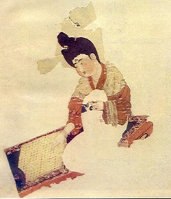
Getting Ready to Learn About the Ancient Chinese Game of Go
"Weiqi, known in English as Go or Encirclement Chess, is one of the four most refined skills that an ancient Chinese intellectual could possess. It has a history of well over 4000 years in China and remains popular to this day in China, Japan and South Korea. Culturally, this may be one activity that really is "more than just a game" .
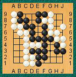
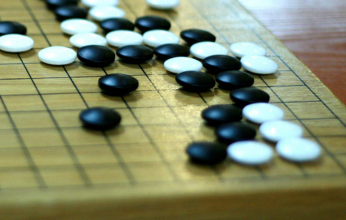
Go is a game of encirclement and capture, which takes place on a board of 361 squares. The object of Go is not to capture the opponent's actual pieces but rather to surround empty territory on the board. This is done by building encircling "walls" around these empty spaces. The game is played by two people, with a black and white set of pieces, just as in chess.
It's pretty certain that Go was invented by Chinese ancestors, yet nobody knows exactly when. The Encyclopedia Britannica records that the game originated from China in 2306 B.C. According to legend, a Chinese ruler of some 2200 years ago, Emperor Yao, invented Go to help enlighten his son Dan Zhu.
Wu Yulin is a Go professional, and coach for young players in the National Go Team. He explains how the game is historically another high-brow art-form.
"In ancient China, Go was mostly favored by intellectuals, especially those from the upper class and the bureaucracy. The ordinary people would seldom take a liking to this game. However, now we have people from all circles playing Go, as a result of government efforts to popularize this ancient art." "
(http://www.china.org.cn/english/features/Archaeology/131298.htm)
The board:
" "You have to become entirely calm, otherwise, you can't play it. In the game of Go you have to be very strong of mind. There's always loss and gain. You might make mistakes during a game, and then have to readjust your mentality in order to fight to the end. For the youth, it can be a failed attempt at learning something new, but for the aged, a hobby like this will greatly reduce the danger of senile dementia."
In fact, all of our minds can benefit from playing Go, which officially has the capacity to make you smarter. Research has shown that that children who play Go have the potential for greater intelligence, since it motivates both the right and left sides of the brain."
(http://www.china.org.cn/english/features/Archaeology/131298.htm)
Check out this Chinese Kids Blog that explains the basic rules of Go for kids:(click on it)
Beijing Kids Blog
Video Tutorial for the Game of Go (part 1)
Check out the rules and strategies here; (click on it)
The Ancient Chinese Rules of Go
From James Davies,
The Rules of Go, in The Go Player's Almanac,
ed. Richard Bozulich, Ishi Press (San Jose, 1992)
Extracted, adapted, and edited by Fred Hansen
Or, check out more general information here: (click on it)
The American Go Association
Let's Look at Models for Today's Activity
Today we are going to create our own artistic representations of a compass rose face. We'll look at samples on this powerpoint presentation to get springboards for creative ways you can design one.
Cool Compass Faces
Cool Compass Faces
Thursday, August 22, 2013
The Week in Review
Well, we've had another great week in Social Studies! Let's think back on what we did.
Next week we will review the parts of a map on Monday, and then launch into map projections in order to include that material on our test for Wednesday. We will finish up our continent maps with one for Asia and one for Australia. We will take a Common Assessment with the other two 7th grade teams on what we have learned, thus far. However, this will not count as a grade - it is simply an assessment "process". We will also touch on the idea of a global community by creating mini-collages on a topic of global importance. I have National Geographic magazines to use for this, but if anyone has magazines at home that their parents are willing to donate, we always accept donations with a smile :).
Some people expressed a concern today that when they tried the absolute location finder on the iTouch map, it didn't seem to work correctly. Below, you will find another link to the World Atlas absolute location finder. Try it by clicking on the link below. See you tomorrow!!!
World Atlas Absolute Location Finder
- We worked on Chapter 2 in our book to prepare for the next unit;
- We watched part of the documentary Brooklyn Castles to prepare for our guest speaker who is coming to introduce the ancient Chinese board game called Go;
- We took notes on the parts of a map in preparation for our test next Wednesday;
- Today we spent the day in the library with Ms. Rummage learning about plagiarism and checking out books;
- And, tomorrow we will have a folder check and create our own artistic versions of a compass rose (and we will get our longitude and latitude tests back to place in our folder)
Next week we will review the parts of a map on Monday, and then launch into map projections in order to include that material on our test for Wednesday. We will finish up our continent maps with one for Asia and one for Australia. We will take a Common Assessment with the other two 7th grade teams on what we have learned, thus far. However, this will not count as a grade - it is simply an assessment "process". We will also touch on the idea of a global community by creating mini-collages on a topic of global importance. I have National Geographic magazines to use for this, but if anyone has magazines at home that their parents are willing to donate, we always accept donations with a smile :).
Some people expressed a concern today that when they tried the absolute location finder on the iTouch map, it didn't seem to work correctly. Below, you will find another link to the World Atlas absolute location finder. Try it by clicking on the link below. See you tomorrow!!!
World Atlas Absolute Location Finder
Tuesday, August 20, 2013
Find Your Absolute Location
Click on the link below, type your address in the box at the top of the page (including city, state and zip code). Then write it down in your composition book.
iTouchMap
iTouchMap
Map Skills
Today we will begin Map Skills in class. We'll take notes from a PowerPoint slide show today to prepare us for our first map skills quiz. Remember that we want to learn how to use a map correctly so we don't have to rely on GPS to find our location or destination! It's of foremost importance for the young geographer!
If you miss some of the notes in class, you can find the PowerPoint on the Map Skills unit blog in the right hand column of this page. Simply click on the unit blog and it will take you there.
For fun, you might want to check out this National Geographic Map Games site:
If you miss some of the notes in class, you can find the PowerPoint on the Map Skills unit blog in the right hand column of this page. Simply click on the unit blog and it will take you there.
For fun, you might want to check out this National Geographic Map Games site:
Chapter 2
Note: Chapter 2 work is officially due on Friday when there will be a folder check. Make sure you have the work completed by Friday when you your 3 brad folder will be checked for a grade.
Thursday, August 15, 2013
Tomorrow's Quiz
Remember that tomorrow's quiz includes:
1) The latitude and longitude notes
2) The latitude and longitude & continent vocabulary
3) The notes we took today on continents
4) Information from your latitude and longitude worksheet
The quiz will consist of labeling a map and thirty written questions. There are NO multiple choice questions!
Good luck and see you tomorrow! :)
Tuesday, August 13, 2013
I Missed You All So Much Today!
I really missed being with you all today! However, I had heat exhaustion and needed rest and hydration. It was not bad enough that we have had so much heat on our hall during the day, but when I got home we had a horrible storm and our neighborhood transformer put about 10 blocks in Central Gardens out of power until 3:00 a.m. Needless to say, my family was debilitated from heat!! However, I can't wait to see you tomorrow!
Let's recap where we are, shall we?
OK, you took notes on latitude and longitude, you've completed maps of the globe, North America and Africa, thus far; you have established your Gaggle accounts and I think we have ironed out all of the problems with the exception of the new students who have never before attended WSMS (we're still working on you!); we completed our Moviesheets on longitude; then you retrieved your latitude and longitude worksheets from Gaggle, and last, but not least, you have submitted your Trip Wow videos. Of course, let's not forget the Textbook work you did in my absence today in the Geographer's Handbook section. We will finish that before the week is out. I think that about covers everything. Check through this paragraph and ensure that you have done everything I have mentioned.
Tomorrow is textbook day, and it happens through the Social Studies teachers. That will take up most of our period for the day. We may get to a little work, but I doubt it.
On Thursday we will complete the Latitude/Longitude worksheets (so make sure you have it with you), and I will do a quick notebook and folder check for a daily grade. I will also give you a study guide for your first quiz which we will have on Friday. I will also give you a vocabulary chart that you will use the glossary in your textbook to fill out for homework over the weekend. By next week, we will use that to begin our first set of flashcards.
I think that about covers everything for the next few days. Can't wait to see you tomorrow!
Thursday, August 8, 2013
Geographic Icon Art Collection
An artist by the name of Jenny O'Dell creates artistic collages out of unusual items. Below you will find one of her latest creations: Satellite Geographic Icons (as seen on Google Maps).
Take a look at these and see how many you can correctly identify. I have an answer key if anyone wants to tackle this one for Enrichment extra credit! Of course, you only get the key when you've finished! You can copy and paste the image onto a word doc or anything that will take a picture so you can get a better look at it if you need to do so. Good luck!
I Have Had So Much Fun This Week!!
I've had so much fun this week getting to know you as groups! I'm sure by now you think, "Oh no! I have a crazy social studies teacher!!" Well, I do like to get your attention with stories and silliness! But, silliness aside, you are all so precious that I look forward to a really great year with you! Of course, you did almost blow up my iPhone on Tuesday night (my battery was so overheated from all the texts!), but we'll let that one slide :)
To the recap the week thus far:
1) We got our Gaggle usernames and passwords (and they work! hooray!);
2) We brought our supplies to school (at least most of us did!) so we can be organized and efficient;
3) We got our first map which was Continents and Oceans (and we know them!);
4) We colored, labeled and cut out the map and glued it in our notebook for future reference;
5) We started (and many finished and submitted) our TripWow vacation video (and remember you have until Monday to finish it);
6) We began our Map Skills Unit with Latitude and Longitude, took notes and watched a quick video on latitude and longitude;
7) Let's not forget that we learned how to comment on the blog!
8) And, so far, last, but not least, we started our map of North America for homework today.
Whew!! We've had a busy few days and it's just the first week!! There's more to come! :) See you all tomorrow bright-eyed and bushy-tailed!
Mrs. Morton
Monday, August 5, 2013
Welcome Falcons!
I want to take this opportunity to welcome all new Falcons to our seventh grade social studies class. I am so excited to be your teacher and can't wait to meet and get to know each and everyone of you.
We have many exciting topics to talk about and projects to do along our journey through geography this year. I hope all of you find it just as interesting and exciting as I do.
We use this blog for all informative daily information, and the teaching blogs to the right of this post for each one of our units of study. You must get used to checking the blog each evening to ensure that you are updated on any new developments for the next day. Please encourage your parents to check in here on a regular basis, as well.
You will notice the tabs across the top. There is important information you need to access on each page tab. Our Instructional map, as well as our syllabus are there. In addition to which, I often post study guides for upcoming quizzes and tests, so you want to make sure you check this page everyday.
I also post important articles, charts, videos, etc. that we will use the next day in class during our lesson. I may even ask you to be prepared for something related to the information, or I may offer points for insightful comments left under the post. So, I can't stress enough how important it is to come here everyday.
The address is: younggeographer.blogspot.com
Please make sure in these first few days that you learn this address.
I know we are going to have a wonderful day today, and I can't wait to meet you!!
Mrs. Morton
Subscribe to:
Posts (Atom)